Hasso-Plattner-Institut
Prof. Dr. h.c. mult. Hasso Plattner
 

Smart Cities and Urban Analytics

The rapid growth in the population density in urban areas leads to new challenges in operational functions, planning, monitoring, management, and control of increasingly smart cities. In recent years, advances in location-acquisition technologies have led to large amounts of time-stamped location information about the flow of vehicles and persons through the city. The capabilities of columnar in-memory databases enable the fast analysis of huge amounts of spatio-temporal data. In different prototypes based on the New York taxi data, we investigate new algorithms and visualization concepts to develop novel applications, which allow users to gain insights in an intuitive way. 

Optimizing Routes of Public Transportation Systems by Analyzing the Data of Taxi Rides

Public transportation systems are flexible and affordable for the passengers. In contrast, the operation and construction of the necessary infrastructure is cost-intensive and requires extensive planning. Decisions about the scheduling, capacities and the location of stations are dependent on various economic, social, and environmental factors and have a major impact on the structure of a city. In this context, information about the starting points and destinations of potential passengers is highly relevant for operators. Unfortunately, the collection of this data is not trivial and often based on time intensive and expensive studies. 

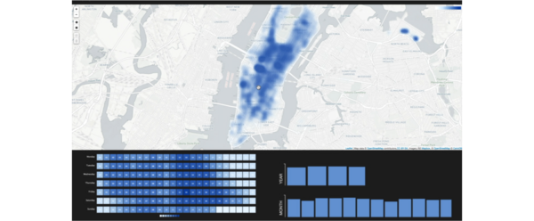
In this project, we developed a novel approach to gain knowledge for transportation system optimization based on the data of taxi rides, which have been recorded for documentation purposes. This data can be analyzed and offers an insight into the fine-grained travel intentions of millions of people. The application enables the exploration of most frequent travel routes and can automatically suggest useful extensions of the exciting transportation system or suggest an optimized route map, which can be used to evaluate the existing one. With this functionality, the presented software effectively supports the decision processes of operators and enables the continuous evaluation of the existing systems. 

An Interactive Visualization of Profitable Areas in New York City

Detailed information about the flow of potential customers in a city is extremely relevant for strategic decisions of various service providers such as taxi companies or advertising agencies. The knowledge about highly frequented regions as well as peak times in specific areas provides a crucial business advantage to competitors. Today, business relevant decisions about the positioning of service providers and advertising spaces or the balancing of capacity are primarily based on experience only. 

In this project, we developed a novel approach to gain knowledge about the distribution of potential customers over time and space based on the data of taxi rides, which have been recorded for documentation purposes. By leveraging the performance of in-memory databases, we build an application, which allows the user to analyze about 700 million taxi rides in real-time. The application allows companies to get an impression in which areas and in what timeframes they can reach a large audience of potential customers. Additionally, we demonstrate that the developed visualization concept enables the comparison of different regions and allows to analyze trends in the customer flow over time. 

Selected Publications

  • Keven Richly, Ralf Teusner, Alexander Immer, Fabian Windheuser, and Lennard Wolf. Optimizing Routes of Public Transportation Systems by Analyzing the Data of Taxi Rides. ACM SIGSPATIAL Workshop on Smart Cities and Urban Analytics, 2015, pp. 70-76

  • Keven Richly, and Ralf Teusner. Where is the Money Made? An Interactive Visualization of Profitable Areas in New York City. EAI Intl. Conference on IoT in Urban Space, 2016, pp. 43-46